Investigating the impact of airborne dust on ambient air quality around Muswellbrook, using a smart low-cost sensing network
"Participating in the OPENAIR program allowed us to explore air quality issues in Muswellbrook more deeply than ever before. Through valuable networking with air quality experts and other councils, we gained fresh perspectives and innovative approaches to air monitoring."
– Sustainability Officer
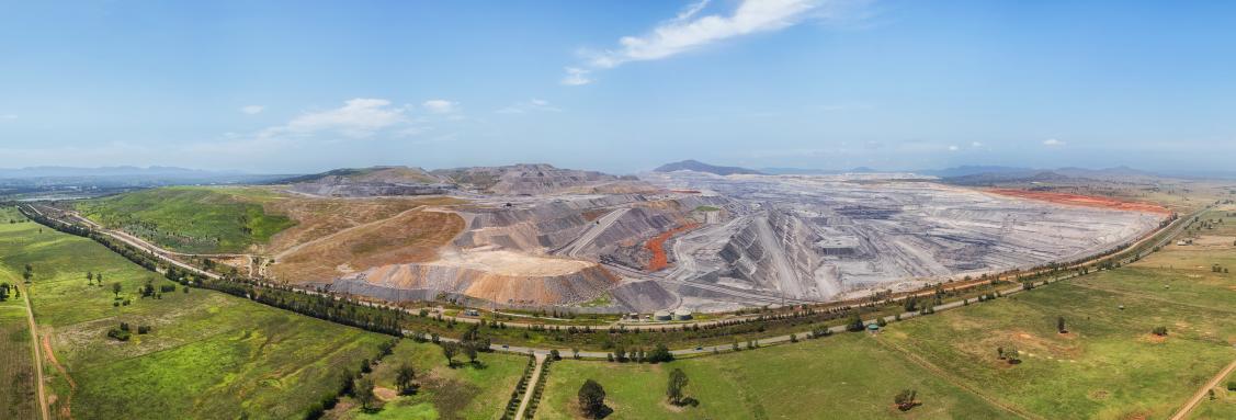
Muswellbrook is situated in the heart of the Hunter Coal Field and at the time of the project, was surrounded by nine active coal mines and two coal fired power stations. In response to community health concerns, Muswellbrook Shire Council installed a network of smart low-cost air quality monitors to measure particulate pollution up and down wind of the town, gathering firsthand data that might indicate the transportation of airborne dust from the mines into the town. The project has significantly increased staff knowledge of air quality science, sensing technology and data, and has provided a foundation for stronger advocacy by Council on behalf of the local community.
Why did Council focus on this issue?
Council had long been aware of community concern about poor air quality associated with the coal industry, and according to a study by Hunter New England Local Health District, asthma and other respiratory conditions are suffered at a higher rate in Muswellbrook than elsewhere in the state. Council disagreed with the NSW State Government position that elevated particulate pollution in the town was the result of smoke from residential wood heaters. They chose to participate in OPENAIR as a way of understanding air quality directly, collecting and analysing their own real-time data rather than having to rely on the monitoring and reporting done by the mining companies, the NSW Government or ANSTO (Australia Nuclear Science and Technology Organisation). It was hoped that new data would help support a case for stronger advocacy to state government, and improved dust control compliance by the mines.
Who was involved in the planning and delivery of the pilot?
Council's OPENAIR pilot project was led by the Sustainability Officer and the Development and Environmental Compliance Officer, with direct support and oversight from the Director of Environmental Planning and Services. Council’s CEO was also aware of and supportive of the project. Staff engaged actively with their counterpart at the City of Newcastle, sharing knowledge and ideas in a localised community of practice that had a shared interest in coal dust as an air pollutant. A PhD Researcher from the University of Newcastle was engaged using an additional funding contribution from Muswellbrook Shire Council. The researcher also worked on the OPENAIR pilot project with City of Newcastle and was able to connect learnings and insights from both locations and support Council with device calibration, deployments, data validation, and data analysis.
The technology
Council was relatively unfamiliar with smart sensing technology and had limited capacity for support within their IT team. They sought a ‘plug and play’ sensing and data storage solution that would not rely upon existing communications infrastructure or inhouse expertise and would produce reliable data that they could trust. The Clarity Node S is a mid-performance multi-parameter compact air quality monitoring device that provides near-real-time data at 15-minute intervals, using 4G communications. Its optical particulate sensor, which is critical for measuring smoke concentrations, has a range of 0-1000mgm3 and a 1mgm3 resolution.
All devices were co-located with a NSW regulatory monitoring station situated in Muswellbrook for three months prior to deployment. They were calibrated to local conditions to ensure data quality. Clarity provided strong active support throughout this process, helping to ensure that Council was confident in the validity of the data that they collected. Devices were connected to the Clarity IoT/Data platform, which provides a range of user-friendly real-time data access, management, interpretation and visualisation capabilities to Council staff. Data is owned by Council and is downloadable from the Clarity platform at any time.

Sensing device deployment
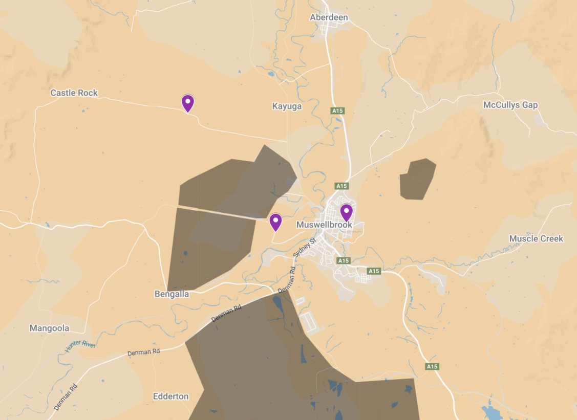
Three devices were deployed, forming a rough transect between local mines and the town of Muswellbrook, aligned with the prevailing wind. Staff knowledge relating to local land, wind and environmental conditions played an important role in site selection. Devices were deployed in April 2023 and were recalled in December 2024 after an operational period of 20 months.
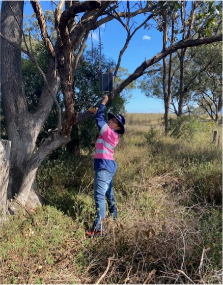
Due to the lack of fixed infrastructure at out-of-town locations, two devices were mounted in trees. The device deployed in town was also mounted in a tree at the Council-owned Muswellbrook Cemetery.
“Every now and then the wind must be going the other way to the prevailing wind, and you get results that you weren't expecting. So then there’d be another source of dust from somewhere [and] we'd have to find what it was. Sometimes there was just no explanation for readings that we got. Anomalies I guess you'd call them. There were parts of town that we thought would be bad, that weren't. And then there were parts of town that we didn't think would be that bad that were… You looked at it and sometimes you just couldn't answer a question… Sometimes you’d find a local cause of poor air quality like a bulldozer near something”
– Sustainability Officer
Challenges and lessons learned
Co-location delays
Council notes time-consuming communication with the NSW Department of Climate Change Energy Environment and Water (DCCEEW) regarding the co-location of Clarity devices at the local monitoring station and a delayed start to the calibration process. This will improve as operational processes are bedded down
Deployment practicalities and location changes
Initial deployment locations had insufficient direct sunlight for solar panels, causing power outages and data gaps. With support from the Newcastle University researcher, more appropriate locations were selected. This included a permanent co-location of one device with a reference-grade particulate monitoring station in central Muswellbrook (a private station funded through the Mount Pleasant mine’s Voluntary Planning Agreement).
Calibration challenges
The team had trouble calibrating their devices with DCCEEW reference equipment, particularly for PM10. There was disagreement between Clarity sensor readings and the reference data, that was not fixed using DCCEEW correction factors. The period for co-location of devices with reference equipment was extended from one to three months. Ultimately, Clarity applied their own correction factor for PM10, however this lacked transparency. Council’s Sustainability Officer noted uncertainty about the Clarity calibration. In response, and in order to develop trust in the corrected output, the project’s PhD researcher is developing a manual calibration for the raw Clarity data against reference data from a nearby ANSTO monitoring station, with direct assistance from ANSTO staff. It is hoped that this will improve Council’s confidence in data validity.
Complex local conditions and processes often made data analysis hard
It became clear that wind direction often varied from the average north westerly prevailing wind direction. The devices deployed did not feature wind sensors, meaning that understanding of wind direction was based on Bureau of Meteorology or DCCEEW data and inferred from comparison of particulate data from the three sensors. In addition, it became clear that there were sources of dust and other particulate pollution in the area other than the mines. This complexity meant that it was sometimes difficult to distinguish elevated particulate levels associated with the mines, from those associated with other sources.
Ongoing Cost
Clarity devices were chosen primarily due to their 4G connectivity, which was viewed as the only via communications option given the lack of local LoRaWAN and public Wi-Fi. The plug and play service, with extensive support from Clarity, worked well during the project as Council lacked internal expertise and capacity that would have been necessary for a more hands-on approach.
Unlike some other solutions, Clarity sensors incur ongoing subscription costs associated with access to the IoT platform and data.
Since project funding ended, Council has not been able to cover ongoing subscription costs with Clarity and due to the proprietary nature of the Clarity devices, they cannot be reconfigured to operate on a private network.
Data and insights
About the data
Following rigorous assessment by the PhD researcher, it was determined that all data sets had an acceptable level of completeness and quality. It was noted that Clarity data diverged from ANSTO reference data during periods of high relative humidity; it is hoped that ongoing work on a correction factor will resolve this. Council staff lacked the expertise or tools required for systematic data analysis, so to date have focused on higher-level observational interpretation of data using the graphic visualisations on the Clarity platform. This has allowed them to identify spikes in particulate matter concentrations and observe general alignment with wind conditions and temperature. For example:
- Data from the device deployed closest to the mines, in a generally downwind position, showed consistently higher particulate levels than data from the other two devices, indicating airborne dust associated with the mines.
Air quality on cold mornings appears to be poorer than at other times, including in town. This is likely a result of a thermal inversion layer, where cold air becomes trapped against the ground with reduced circulation and a subsequent accumulation of air pollution.
More thorough statistical analysis of the data is being undertaken by the University of Newcastle PhD researcher. One or more academic papers are currently undergoing peer review and an internally facing report with key findings will be produced for Council.
Data sharing
Muswellbrook Shire Council lacked a discreet data policy that might inform a position on sharing of project data. Staff noted that the project highlighted this policy gap, contributing to a case for future policy development.
Project data has not been shared with any third parties or with the public. This is attributed to a lack of capability within Council’s IT department, and concern from senior management that high readings might upset or scare the community members at a time when Council does not have full confidence in how to interpret and communicate the air quality measurements to the general public.
When asked what might change Council’s position on data sharing, the Sustainability Officer emphasised resourcing and time. They explained that existing Council IT systems were not able to host live sensor data, or facilitate managed data sharing, indicating that upgraded systems would likely be required, alongside staff training and upskilling with IoT technology. Beyond this they emphasised the need for more staff time, to support the work needed to build greater confidence in data, and the processes of good data governance.
“Our manager was very very keen for the data. Very keen to be involved. And it gave [Development and Environmental Compliance Officer] and I time to collaborate on this, and that was really good… We've learned things that we would never have learned if we hadn't been involved. It's always nice to be involved in projects like this with people from universities... It's always good to be able to pick the brain of someone who knows more than you do.”
– Sustainability Officer
Creating impact
The OPENAIR pilot project has resulted in the following positive impacts:
Upskilling and confidence building for Council staff
Council staff who worked on the project have emphasised the value of OPENAIR participation in terms of what they learnt about air quality and sensing technology. The experience has given them greater confidence to speak with community, state government and the mining industry about the issues.
External engagement
Although detailed project data has not been released to the public, the project itself has been widely promoted as a positive local initiative. It received attention in internal communications to all council staff and has featured in a local newspaper article and a discussion on local radio.
Looking ahead
The upcoming report on data insights and the accompanying academic papers should establish a more grounded position that Council staff can use to bolster their advocacy efforts at local Community Consultative Committees (CCCs). This work may also provide a foundation for sharing of the new sensor data with the public and other public bodies.
Council’s Sustainability Officer has indicated a desire to continue monitoring throughout the year to improve understanding of seasonal periods with more pronounced dust issues. This includes mid-winter, when thermal inversion layers are most likely to trap pollution at ground level, and mid-summer, when dry and windy conditions result in elevated dust production and dispersal. The hope is that new data can support targeted interventions that reduce dust issues during these high-risk periods.
There is an intention to look at Nitrogen Dioxide (NO2) data as a way of distinguishing traffic pollution and wood smoke from dust. This may help to characterise the nature of particulate pollution, addressing Council’s original hypothesis that air quality issues in Muswellbrook are linked to the mines, rather than just smoke from wood heaters. There is also a general interest in baselining road traffic emissions in Muswellbrook, ahead of an anticipated future bypass.
The issue of viable future monitoring was raised, in light of the challenge of financing an ongoing subscription service with Clarity. The Sustainability Officer has noted interest in alternative lower-cost open technology options such as Purple Air sensors, referencing the 4G-to-Wi-Fi backhaul and solar power solution implemented by Tweed Shire Council as part of their OPENAIR pilot project. Purple Air was also mentioned in the context of school projects, which might support a more participatory future approach to community engagement.
“You've got 2 people in council that are now highly interested in [the issue]. And we're not really going to let it go… [We] go to the coal mines and the CCCs as well, so we can hear about air quality stuff that's going on there, and we can also say, ‘Hey, we did this, and this is what we found. It's not really agreeing with what you're saying there’.” – Sustainability Officer