Investigating air quality around Gold Coast airport
| Dates | November 2021 - May 2023 |
| Locations | Uki, Tweed Heads West, Tweed Heads South |
| Issue | Particulate matter pollution associated with the Gold Coast airport |
| Sensing devices | 3 Purple Air devices |
| Data measured | Temperature, humidity, particulates (PM2.5, PM1) |
| Communications technology | 4G (LTE), retrofitted backhaul behind Purple Air Wi-Fi |
“Participating in the OPENAIR program was a valuable experience. The program provided insights into relevant technologies and access to a knowledgeable expert network, fostering effective collaboration both inside and outside the Council organisation.”– Environmental Health Officer
Gold Coast airport is one of the busiest regional airports in Australia, with around 100-120 flights per day. Residents living under the flight path have voiced concern, based on a belief that planes may be generating hazardous air pollution. In an effort to explore this concern, Tweed Shire Council installed a small network of smart low-cost air quality monitors to measure particulate pollution in the area. The aim was to identify whether discernible elevations in particulate concentration could be identified under the flight path, relative to a control location outside of the flight path. It was hoped that this would support a more informed position for Council, from which to respond to the community and engage with airport management.
Why did Council focus on this issue?
Tweed Shire Council’s Community Strategic Plan emphasises good air quality as part of a high quality of life for residents, providing a foundation for participation in the OPENAIR project.
The Gold Coast Airport is one of the largest industrial operators that is located – partially – within the Tweed Local Government Area (LGA). The council resolved to join the project to investigate community concerns about potential aviation-related air pollution, leveraging existing PurpleAir monitoring devices that were previously procured but not yet utilised. It was felt that Council should seek to understand whether or not air pollution was measurably higher under the flight path, and whether this might be attributable to aviation, with the aim of being better informed when responding to community concerns.
Who was involved in the planning and delivery of the pilot?
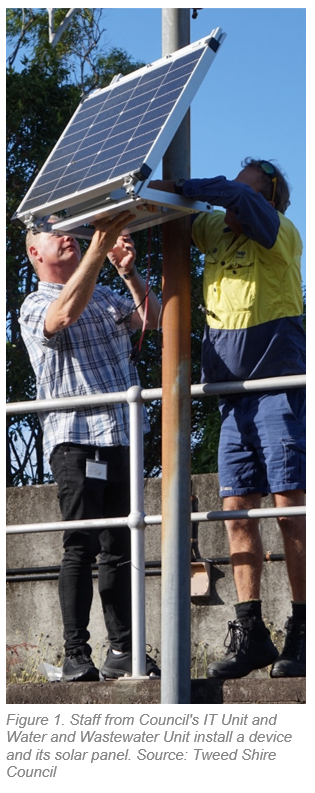
Council's OPENAIR pilot project was led by an Environmental Health Officer, with support from the Environmental Health Team Leader and Environmental Health Manager. Technical support and assistance with equipment installations came from Council’s IT department, and staff from Council’s Water and Waste Water unit supported access to deployment locations. Council’s General Manager was aware of and supportive of the project, as were the Mayor and Councillors, who were keen to explore community concerns around possible aviation-related air pollution. Project participation was endorsed through council resolution.
The technology
The project made use of PurpleAir devices that were procured through a previous initiative but never deployed. A key challenge with PurpleAir devices is that they require a supply of mains power and Wi-Fi communications, which can significantly constrain where they can be deployed. In order to deploy them in relevant locations under the flight path, devices were retrofitted with a custom solar power, battery and 4G communications solution, designed and implemented by Newcastle-based smart technology integration contractor SAPHI.
PurpleAir offers a mid-performance low-cost sensing solution for particulate matter measurement. PurpleAir devices incorporate two Plantower particulate matter sensors that produce reliable PM2.5 and PM1 data across an effective range of 0-500 µg m−3[i]. PM10 data from these sensors is available but difficult to validate and is considered to be mostly unusable without extensive device calibration and data correction work[ii].
PurpleAir devices are registered to the PurpleAir online platform, which receives, interprets and visualises the measurement data. Data can be viewed and downloaded through a password-protected user portal. Access is free of charge and unrestricted for the lifetime of the device. The data is owned by the device user.

Figure 2. Simple data architecture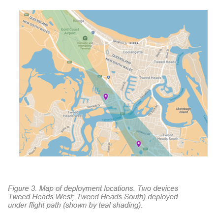
Sensing device deployment
Three devices were deployed in April 2023, with two under the main aircraft flight path and one in a control location at Uki (30km south west). Devices operated 12 months before losing functionality in May 2024.
All devices were deployed at Council-owned water treatment facilities, which streamlined approvals and resolved security concerns through restricted public access. These facilities were non-operational because operational wastewater facilities produce airborne particulate matter that can interfere with readings. Deployments were approved by Council’s Water and Wastewater Unit, which supported the project directly by installing the equipment.
Data and insights
About the data
The devices and their retrofitted power and communications systems operated correctly and continuously throughout the project period, providing a mostly complete data record across 12 months of operation. However, due to limited resourcing and expertise, data quality assessment and analysis were not conducted, limiting the project’s ability to address the research question. It was also determined that rigorous study of aviation emissions around an airport likely requires the use of more costly sensing equipment that is able to capture more accurate data. Staff also noted that they lacked (or otherwise never accessed) contextual data – such as flight schedules and weather – that would be critical for usefully interpreting the air quality data that they collected.
Data analysis was never undertaken because the skills required for it did not exist on the project team and (despite some discussion of potentially engaging a PhD student) there was no budget assigned to support data analysis by a third party. At some point after formal wrap-up of the project, all three devices ceased reporting data. The team is unsure why this happened but hope to address the issue when resourcing allows.
Data sharing
At the time of the project, Tweed Shire Council lacked a discreet data-sharing policy that might have informed a position on sharing of project data. This was not considered to be a concern, as the focus of the project was not about community engagement or public data release. Rather, it was about exploring the use of low-cost air quality sensors as tools for enhancing Council’s air quality monitoring capabilities, developing internal understanding of the air pollution issue, and building skills and knowledge through collaboration and knowledge transfer with industry experts and peers.
Considerations by Council were made regarding additional workload that might be associated with addressing community concerns, following any public release of data. Effectively responding to such concerns would require Council to have confidence in interpreting the data and adopting an authoritative stance on its implications; outcomes which were not achieved. It is also important to note that aviation-related air pollution falls outside the direct responsibilities and jurisdiction of the Environmental Health Unit. Consequently, no operational funding was allocated to support the public dissemination of this data or to manage community responses. In this context, the decision not to release the data publicly was considered a pragmatic approach, allowing the Council to maintain its focus on core environmental compliance and regulation responsibilities.
Data was shared with the NSW state government via an API, supporting the experimental OPENAIR pilot data stream, which aggregates and harmonises data from multiple different Council monitoring networks across NSW. The decision to do this was made informally by the project team and was not the result of any structured data governance process.
Creating impact
The OPENAIR pilot project has resulted in the following positive impacts:
Upskilling and confidence-building for Council staff
Council staff who worked on the project (5 in total) have emphasised the value of OPENAIR participation in terms of what they learnt about air quality, smart sensing technology and data. While the data produced during the project has failed to deliver any insights, the team do engage with other environmental issue (like noise and water quality) where smart sensing is relevant. They look forward to employing their new knowledge in these other contexts.
Collaboration between Council units
The Environmental Health team commented on the strong collaboration between their unit, the IT unit and the Water and Wastewater Unit, noting that the project has built working relationships and trust between staff.
Engagement with concerned community members
A presentation about the project was made to the local CACG (Community Aviation Consultation Group) by Council’s Environmental Health Officer.
Challenges and lessons learned

Figure 4. A plane landing at Gold Coast international airport. Source: Getty images
“We had to balance security issues, proximity to flight paths and… actually being able to capture any sort of data from the aircraft… We needed to consider whether to install any additional structures… access and approval… There's so many things we had to look at.”
– Environmental Health Officer
Insufficient internal resourcing
The project required significantly more staff time than anticipated, posing a challenge for the Environmental Health team, who struggled to balance project activities with their core responsibilities. This limited the project’s ability to deliver actionable insights, underscoring the need for adequate resourcing in future initiatives.
Insufficient internal knowledge and expertise
PurpleAir devices are cost effective in large part because they have no external technical support and rely upon an inhouse DIY approach. While advice and information is available through a large global community of users, a baseline of technical knowledge and expertise is required of users in order to correctly calibrate devices, collect useable data and extract clear insights. This expertise was lacking within Council, leading to minimal technical oversight and no one to lead technical tasks. Consequently, best practices for experimental design, device calibration, deployment, and data management were not followed. For example, devices were not co-located with NSW regulatory monitoring stations before deployment, affecting data trust and interpretation.
Selection of deployment locations
Identifying appropriate deployment locations that were under the flight path, accessible, secure, Council-owned, and able to support the mounting of equipment was a key challenge. Physical installation of bulky solar-panels by the in-house team, while complying with WHS requirements, was a related challenge. This all led to a protracted process and only three out of a possible ten devices were deployed. Use of Council water treatment facilities, and collaboration with Council’s Water and Wastewater Unit, delivered a limited but workable solution.
Looking ahead
Tweed Shire Council’s OPENAIR pilot project highlights the challenges of addressing aviation-related air pollution, which falls outside local government regulation and the core responsibilities of the Environmental Health unit. This disconnect, combined with resourcing and expertise constraints, limited the project’s ability to deliver value. Despite this, council’s participation in OPENAIR positions council to better leverage smart sensing technology in future initiatives.
The Environmental Health team identified smoke from cane and backyard burning as an air quality concern with clear community impact and alignment with their core responsibilities. While Council does not regulate cane burning, a policy on backyard burning exists, and a future air quality monitoring program could inform policy updates. The team also expressed interest in smart sensing for water quality monitoring, which aligns with their compliance work.
In order to succeed and deliver meaningful outcomes, any future smart sensing projects at Council will require a clear business case, robust resourcing, clear ownership by Council staff, and enhanced technical and data management capabilities.
“For future projects, local councils would benefit from enhanced operational support to ensure effective ongoing maintenance. A clearer understanding of the resources required to manage such initiatives is essential. Providing robust guidance on setting achievable and realistic project scopes will be critical to their success.”– Environmental Health Officer
[i] https://www2.purpleair.com/products/purpleair-pa-ii?srsltid=AfmBOornAGdt6TxFDCMzQh9rm8V8jIrVbtzg00tuvC3GmkogJbIwZ6i
[ii] Stavroulas, I., Grivas, G., Michalopoulos, P., Liakakou, E., Bougiatioti, A., Kalkavouras, P., ... & Gerasopoulos, E. (2020). Field evaluation of low-cost PM sensors (Purple Air PA-II) under variable urban air quality conditions, in Greece. Atmosphere, 11(9), 926.