City of Newcastle’s low-cost sensor network
| Dates | March 2023 - ongoing |
| Locations | Beresfield, Callaghan, Carrington, Lambton, Stockton, Mayfield, Merewether, Wallsend |
| Issue | Particulate matter pollution associated with coal dust |
| Sensing devices | 9 Cyplex TICTOC LoRaWAN mini ultrasonic weather stations (deployed at 8 locations) |
| Data measured | Temperature, humidity, pressure, wind, precipitation, particulates (PM10, PM2.5, PM1) |
| Communications technology | LoRaWAN (NNNCo) |
“OPENAIR was a great experience that allowed the City of Newcastle Council to downscale and localise an air quality network. The knowledge sharing, workshops, and funding provided through the program helped develop and shape our low-cost air quality sensor project.”
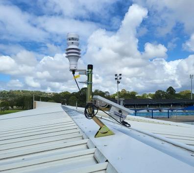
The City of Newcastle ran a project to monitor and characterise airborne coal dust in residential suburbs adjacent to a railway line and coal stockpiles associated with coal export activity from the Port of Newcastle. Nine smart weather stations with integrated particulate pollution sensors and real-time data reporting were deployed at public swimming pools.
The project developed a strong focus on data validation, with the aim of establishing improved understanding of and trust in the data being produced. Devices were successfully calibrated to account for variations in humidity (a major interference factor for low-cost particulate sensors) and were proven to produce reliable and accurate PM2.5 and PM10 data at low concentrations (down to 3mgm3). This creates a foundation for ongoing Council investigation into the coal dust issue.
Why did Council focus on this issue?
The project was grounded in priorities established in Council’s Community Strategic Plan, Newcastle2040, that includes priorities of Action on Climate Change. The Council understands the intersection between air quality and climate pressures, and has a commitment to nature-based solutions that promote clean air quality. It also hears from the community about concern about coal dust, air quality and health in areas with high industrial activity.
Who was involved in the planning and delivery of the pilot?
The project was established within Council’s Smart City team, then subsequently moved to the Climate Change and Sustainability team where a more impact focus emerged. The Climate Change and Sustainability Manager emphasised the complexity of air quality monitoring, noting that Council does not and should not have that level of specialised expertise. This justified Council’s partnership approach with university experts through OPENAIR. Notably, Council matched OPENAIR funding to engage a PhD student from the University of Newcastle, who led the experimental design, device calibration, data collection and analysis, and authored multiple academic papers (currently undergoing peer review). Council activities were supported by the IT department (which assisted with LoRaWAN communications) and Property Services (which supported sensor deployments at public pools).
The technology
The compact ultrasonic weather station features an optical particulate sensor with a range of 0-500mgm3 and accuracy of +/-10%. All devices were co-located with NSW regulatory monitoring stations prior to deployment and were calibrated to local conditions to ensure data quality that Council can trust and utilise publicly. They provided near-real-time. Council made use of the existing city-wide NNNCo LoRaWAN network, NNNCo-configured weather stations, and NNNCo IoT platform for hosting, storing and interpreting data. The device was easily accessible for custom configuration.

Sensing device deployment
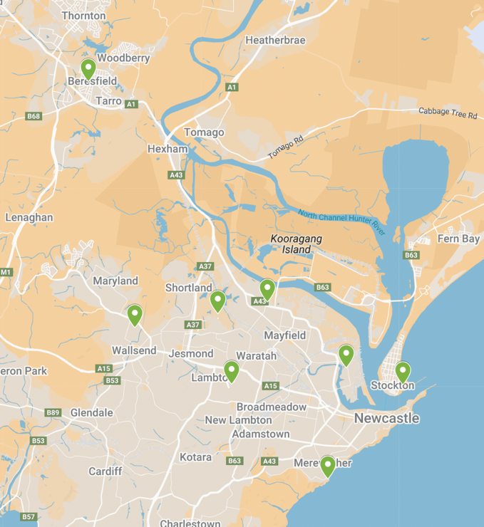
The aim was to monitor particulate pollution characteristic of coal dust within residential locations close to industrial coal facilities. Regulatory monitoring stations at Carrington, Mayfield, Wallsend supported this, and provided an opportunity to co-locate low-cost sensors with regulatory-grade monitoring stations for calibration purposes. Public pools in suburbs like Stockton and Lambton provided additional deployment sites that were well-distributed, Council-owned, had good solar exposure, and overnight security. Comparison locations were also used, including one inland (Beresfield) and one coastal (Mereweather).
Figure 2. Map of deployment locations
Challenges and lessons learned
Technical challenges
Four devices had inconsistent data capture, with less than 75% completeness. This is attributed to shading of the solar panel (causing devices to periodically lose power) and ‘data glitches’ (bugs and irregularities that can occur at various points in the system, from the device, through communications to the IoT platform). One of these devices, deployed next to the ocean, suffered complete failure due to salt corrosion of the battery and solar panel. Despite these challenges, the five remaining devices captured enough data from distributed locations to support the aims of the study.
Data and insights
About the data
“We really want to be confident about what we're saying with low-cost sensor measurements. [The technology] is already highly criticised. So I'm really making sure, using my calibration and distribution models, that everything has been rigorously scrutinised and corrected.”
– PhD Research lead
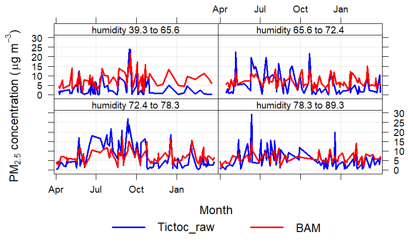
One year of continuous data was used for the pilot project data analysis (March 2023 to March 2024). The analysis has focused on the correlation of PM2.5 and PM10 data from low-cost sensors with data from regulatory-grade monitoring stations. The aim has been to understand why variation occurs relative to changing environmental conditions. A key finding has been that high Relative Humidity (RH) caused low-cost sensing devices to significantly over-report particulate concentrations. Coastal NSW has humidity levels that are consistently much higher than northern hemisphere continental conditions where the sensors were designed and calibrated. The project’s PhD researcher developed a custom calibration to overcome this.
Data correction and validation has been viewed by Council as the essential precursor to broader analysis of the data in terms of the spatial distribution and behaviour of coal dust and other local pollutants.
Data sharing
To date, no data has been shared with the public. This is because the project has been about building greater confidence in the data so that Council is able to adopt a defendable position on a contentious community issue like coal dust. The data validation work that has formed the core of the pilot project research is currently undergoing academic peer review. Once the research has been accepted for publication, Council will review its position on public data sharing.
Creating impact
“The OPENAIR workbooks and best practice resources were an air quality module for Councils to follow. It was really good and clearly laid out what needed to be considered, saving our team a lot of time and effort.”
– Climate Change and Sustainability Manager, City of Newcastle
The OPENAIR pilot project has resulted in the following positive impacts:
Up-skilled staff
Council’s Climate Change and Sustainability Manager reports that participation in OPENAIR has resulted in them becoming “heavily upskilled” and other staff “moderately upskilled” on air quality complexities in the Newcastle area, and in the technology and data associated with air quality monitoring.
Building an active community of practice for regional Councils
Council’s Climate Change and Sustainability Manager has emphasised the value of an emerging local government community of practice around air quality in the region, with connections made between counterpart staff members in neighbouring LGAs, as well as with university experts.
Significant steps towards reliable trusted and useable data
The validity of data from low-cost air quality sensors is often questioned. In order to take public positions on local air quality, particularly relating to a contentious issue like coal dust, City of Newcastle must have high confidence in data validity, and be able to use data in ways that stand up to external scrutiny. The OPENAIR pilot project has successfully engaged with this challenge through rigorous assessment of how local environmental conditions such as high humidity, salt aerosols and wind interact with sensing device performance. In close collaboration with the NSW Department of Climate Change Energy Environment and Water, low-cost devices were calibrated to local conditions and appropriate data correction factors were formulated with reference to regulatory-grade monitoring stations. The process and solutions are undergoing academic peer review, and it is hoped that papers will be published later in 2025. This work provides a strong foundation for Council to begin confidently exploring the nature and scale of localised air quality issues in Newcastle.
Looking ahead
Council hopes to start using data from their new sensing network to explore whether localised exceedances of PM2.5 and PM10 pollution are occurring, noting that state-managed regulatory stations are limited in terms of their ability to capture highly localised conditions that might relate to adjacent industrial activity. Once Council determines what is happening, where, and why, then they can develop evidence-based strategies to address air quality challenges. They also hope to use new data as the basis for engagement with the NSW Government, as a way of advocating on behalf of community for investigation of localised pollution issues and industrial compliance concerns. A desire to develop a strong working relationship between Council and state government was emphasised, grounded in shared access to trusted data.
Council is also interested in using their new sensing network to understand localised urban heat variations during heatwaves and communicate elevated heat risk to community by geographical area.